Radar, GPS & Speedometer - USA
- 4.0
- Rating
- 1.00M
- Installs
- Free
- Price
 Analysis by App-foxy
I approached Radar, GPS & Speedometer as a practical driving companion rather than a replacement for a full navigation service. Its main appeal is concentration: it puts radar warnings, speed information, a heads-up display, radar maps, and a trip summary into one focused tool. After using it in that role, my view is clear: it is most useful for drivers who already know where they are going and want extra awareness on the road, not for someone looking for turn-by-turn route planning from one app.
The app is free to start, available for Everyone, and works on devices running Android 6.0 or later. It comes from Bilge Bulut Mobile and has built a strong audience, with more than a million installs and an average rating of 4.6 from roughly three thousand ratings. Those figures suggest that the central idea is easy to understand and valuable to many drivers. The important question, though, is whether its focused approach fits your daily driving habits.
What makes the driving experience useful
I find the driving experience most useful when I decide what I need from the screen before I set off: a quick speed check, a look at radar information, or a glance at the trip afterward. Keeping those purposes distinct helps me avoid turning a focused companion into another map to manage while moving. That practical balance also makes it easier to see where a broader navigation tool may suit a different kind of journey.
You May Also Like

 Blood Strike: 2.5 Anniversary
Blood Strike’s Loadouts Turn Every Drop Into a Tactical Gamble
A close look at Blood Strike’s custom loadouts: how fast access to signature weapons reshapes its battle royale rhythm, rewards preparation, and narrows the gap between fights.

 Pandora - Music & Podcasts
Pandora’s Music Is Easy to Start, but Harder to Recover
Pandora’s strength is its low-effort path from a seed to a station. Its weak spot is how much confidence it asks you to place in connection, setup, and quiet recovery.

 8 Ball Pool
 Is Built on Rivalries, Rematches, and Routine
A close look at the rivalries, rematches, shared routines, and unanswered safety questions that turn a quick pool match into a persistent mobile community.

 Samsung Music
’s Quiet Strength Is Playing What You Already Own
Its reach comes less from spectacle than from dependable access to a personal library. That simplicity is both the app’s strongest retention engine and its ceiling.

 AccuWeather: Weather Radar
AccuWeather Review: A Quick, Clear Forecast for Everyday Decisions
For everyday plans, the best forecast is the one you can understand quickly. AccuWeather makes rain timing, radar, and local conditions easy to act on, with a few trade-offs.

 Hill Climb Racing
Why Hill Climb Racing Still Turns Crashes Into One More Run
A tiny car, a bumpy hill and one more upgrade: Hill Climb Racing keeps resurfacing because its simple chaos makes every near-miss feel personal.
More From Our News Desk



A focused dashboard for drivers who want fewer distractions
The first strength is the app’s narrow purpose. Instead of trying to be a complete travel platform, it centers the information that matters when I am already on the road: current speed, radar-related awareness, and a quick view of the trip. That makes it easier to treat the screen as a secondary instrument rather than as a place to search, plan, message, and manage several unrelated tasks.
I found this especially helpful before setting off on an unfamiliar road. I can choose my navigation route in the service I normally use, then use this app as an additional layer for speed awareness. That division of labor is sensible. A dedicated map service is usually better for live route changes, addresses, and traffic decisions, while this app can keep attention on the driving information it is designed to present.
The speedometer is the most immediately understandable part. A large, readable speed display is useful when I want a quick visual check without interpreting a complicated map. It also encourages a better habit: checking speed before a long downhill section, after leaving a slower urban road, or when the road layout changes and my sense of pace becomes unreliable.
Radar maps are more useful before the journey than during complicated navigation
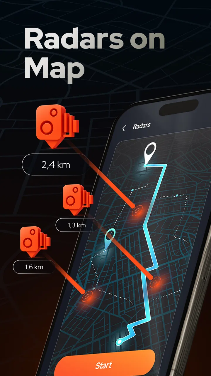
The radar map gives the app a planning role as well as a live-driving role. Before leaving, I can look at the route area and think about where extra care may be needed. That is more useful than treating warnings as surprises that appear only after I am already committed to a road. I prefer this kind of preparation because it makes the app part of a calm routine rather than a source of sudden screen-checking.
There is also a subtle trade-off here. A map full of markers can be informative when the car is stationary, but it is not something I should study while moving. My practical workflow is to review the map before departure, start the relevant driving view, and then keep interaction to a minimum. This is one of the app’s better use cases: it rewards preparation and discourages unnecessary fiddling once the journey begins.
For a regular commute, the same approach can become even more convenient. After learning the roads, I do not need another complex map interface competing for attention. I can use the app as a familiar check on speed and road awareness while relying on memory or a separate navigator for the route itself.
The heads-up display is valuable when it reduces glances, not when it becomes a novelty
The heads-up display is the feature I would judge most carefully. Projecting driving information in a way that can be read with a shorter glance sounds appealing, but its real value depends on how it is used. I would set it up before moving, place the phone securely, and check that the reflected view is readable in the actual lighting conditions. A feature intended to reduce distraction can have the opposite effect if I spend time adjusting it on the road.
In daylight, reflections, dashboard position, and screen brightness can affect how comfortable the display feels. At night, an overly bright screen can also become irritating. I would therefore treat the heads-up view as a convenience to test, not as an automatic improvement for every vehicle. Drivers who already have a clear speed display may gain little from it, while someone whose dashboard is difficult to read could appreciate the alternative view.
My strongest tip is to decide on the display arrangement while parked. Place the phone where it remains stable, confirm that the information is visible without blocking the road, and only then begin driving. That simple preparation makes the feature more practical and avoids turning a useful idea into a fiddly distraction.
Trip summaries add context that a live speed reading cannot
The brief trip view gives the experience a useful closing step. A live speedometer tells me what is happening now; a trip summary helps me reflect on the drive afterward. Even a short review of a journey can reveal patterns, such as spending more time than expected on fast roads or needing to be more attentive during a particular part of a regular route.
This is where the app can become more than a warning screen. I can use it as part of a simple driving routine: prepare the route, drive with the dashboard visible, then review the trip once parked. That workflow is particularly suitable for people who want to become more deliberate about their driving without keeping a detailed manual log.
At the same time, I would not mistake a brief summary for a complete driving record. Someone who needs professional-grade fleet reporting, detailed expense documentation, or comprehensive journey analysis should look for a specialized tool. This app’s summary is best understood as a quick personal overview, not as a replacement for dedicated transport software.
What the app feels like in everyday use
Imagine a weekday drive to a nearby town. I already know the destination, but the route includes a mixture of local streets and faster roads. Before leaving, I check the radar map, start the driving display, and keep the phone positioned so the speed is easy to see. During the trip, I use my normal navigation app for directions and let this one handle the extra awareness. When I arrive, I can look back at the trip rather than trying to remember every change in pace.
That scenario shows the app at its best. It is not overloaded with tasks, and it does not need to become the center of the journey. It quietly supports a driver who wants a clearer speed reference and a little more preparation around radar information. The experience is less compelling if I expect one application to handle route search, traffic, roadside information, and speed monitoring with equal depth.
Where it sits beside ordinary navigation alternatives
Compared with a standard navigation app, Radar, GPS & Speedometer has a more specialized identity. Conventional navigation tools are usually stronger when I need a destination search, spoken directions, route alternatives, traffic context, or a broad map ecosystem. I would choose those first for a complicated trip in an unfamiliar city.
This app makes more sense beside them. Its focused speed display and radar-oriented presentation can fill a gap that a general map sometimes treats as secondary. That is a meaningful distinction, not a weakness by itself. A tool does not need to replace every other tool if it performs one driving task in a clearer way.
Compared with a basic standalone speedometer, it offers more context through radar maps, the heads-up display, and the trip view. A simple speedometer may be preferable for someone who wants almost no setup and only needs a large number on screen. I would choose this app when I want speed information connected to a broader driving-awareness workflow, but I would choose the simpler alternative when minimalism matters more than additional views.
The limitations I noticed before recommending it
The biggest limitation is scope. The app’s store summary emphasizes travel with radar information, speed-camera awareness, a heads-up display, radar maps, and a brief trip view; it does not present itself as a full navigation replacement. That means I would not install it expecting it to solve every problem associated with a long journey. If I need dependable route guidance and live traffic decisions in one place, my usual navigation service remains the better primary tool.
There is also a practical responsibility attached to any speed-camera or radar-warning app. Road information can change, and a warning should never encourage me to stare at the phone or treat the app as permission to drive carelessly. I use the information as a prompt to stay attentive and obey posted limits, not as a guarantee that every road condition will be represented perfectly. The driver remains responsible for watching the road and following local rules.
The heads-up display can introduce its own friction. It needs a sensible phone position and may not suit every dashboard or lighting situation. If I cannot read it comfortably without adjusting the device, it loses its main advantage. I would rather use a straightforward speed view than force a display mode that makes the setup more complicated.
The free entry point is attractive, but the app also includes in-app purchases ranging from $2.99 to $29.99 per item. That does not make the app poor value, but it does mean I would check which functions are included before committing to a paid upgrade. A driver who only wants the basic experience may be satisfied without spending more, while someone expecting every convenience to be unlocked immediately should review the purchase choices carefully.
Another consideration is the age of the device. Support for Android 6.0 or later makes the app accessible to many users, but older phones may provide a less comfortable experience than newer hardware, especially when the screen is small or brightness is limited. I would test readability while parked rather than assuming that compatibility automatically means an ideal dashboard experience.
Who will get the most from it
I recommend this app to drivers who already have a preferred route planner and want a dedicated companion for speed awareness. It is a particularly good fit for regular commuters, people who drive through unfamiliar areas but do not need another full navigation system, and users who like reviewing a journey after reaching their destination.
It can also suit drivers who appreciate a configurable-feeling dashboard experience, especially if the heads-up presentation is comfortable in their vehicle. The best results come from people willing to prepare the screen before moving and keep interaction brief. In my experience, that mindset matters more than simply installing the app.
I would be more cautious about recommending it to someone who wants an all-in-one navigation solution. If your main need is finding addresses, receiving detailed spoken directions, comparing routes, or reacting to traffic, a mature navigation platform is likely the better first download. I would also skip it if I rarely drive, have no interest in radar-oriented information, or prefer not to mount a phone where it can be seen.
It is not the right choice for drivers looking for formal fleet management or deep professional reporting either. The trip summary is useful for personal reflection, but a business workflow may demand records and controls beyond the app’s focused consumer design.
Small habits that make the app work better
My first recommendation is to separate planning from driving. Review the radar map while parked, choose the route in the appropriate navigation tool, and then start the driving view. This reduces the temptation to explore the map while the vehicle is moving and makes the app feel calmer.
Second, use the speedometer as a regular visual reference rather than waiting for a warning. Checking speed during transitions between road types is more useful than relying only on alerts. It also makes the app valuable on roads where radar information is not the main concern.
Third, test the heads-up display on a short familiar trip. That lets me judge reflections, placement, and readability without adding pressure to an unfamiliar journey. If it does not suit the car, the app still has value through its ordinary driving view and map-based preparation.
Finally, look at the trip summary only after parking. The summary is most useful when it encourages reflection, not when it becomes another reason to interact with the phone during the drive. These habits turn the app from a collection of features into a sensible sequence: prepare, drive, and review.
My final assessment of the free driving companion
After weighing its strengths against its boundaries, I see Radar, GPS & Speedometer as a focused and useful companion rather than a universal road app. Its combination of speed monitoring, radar maps, heads-up presentation, and short trip feedback gives it a clear identity. The experience works best when I pair it with a conventional navigator instead of asking it to replace one.
The app is free, rated for Everyone, and currently listed at version 5.3, giving it an approachable starting point for everyday drivers. The paid items may matter depending on which extras a user wants, so I would explore the free experience first. That is also the fairest way to judge whether the display style and workflow suit a particular phone and vehicle.
My recommendation is straightforward: choose it if you want a dedicated speed-and-radar companion, not if you want complete navigation in one package. Used with sensible preparation and attention to the road, it can make routine driving more informed and organized. Its value comes from doing a smaller job with a clear purpose, and that is exactly why it will appeal to some drivers much more than a crowded all-in-one alternative.
FAQs for Radar, GPS & Speedometer - USA
01What features does Radar, GPS & Speedometer offer?
Radar, GPS & Speedometer provides real-time navigation and speed tracking using GPS technology. It includes features such as speed alerts, route optimization, and live traffic updates. Additionally, the app offers a radar detector feature that warns users about speed cameras and potential speed traps, enhancing safety on the road.
02Is Radar, GPS & Speedometer available for both Android and iOS?
Yes, Radar, GPS & Speedometer is available for download on both Android and iOS platforms. You can find it on the Google Play Store for Android devices and the Apple App Store for iOS devices. Make sure your device meets the app's system requirements for optimal performance.
03Does the app require an internet connection to function?
While Radar, GPS & Speedometer can operate offline, many features such as live traffic updates and real-time radar alerts require an internet connection. For the best experience, ensure your device has a stable connection when using these features. Offline mode is available for basic navigation and speed tracking.
04Are there any in-app purchases or subscription fees?
Radar, GPS & Speedometer offers a free version with basic features, but it also includes in-app purchases for premium features like advanced radar detection and ad removal. Subscriptions might be available for additional functionalities. Check the app store listing for detailed pricing and subscription options.
05How accurate is the GPS and speed tracking?
The GPS and speed tracking in Radar, GPS & Speedometer are highly accurate, relying on your device’s built-in GPS hardware. However, accuracy can be affected by factors such as signal strength, device settings, and environmental conditions. Regular updates help maintain accuracy and performance.
Pros
- Accurate real-time speed tracking.
- User-friendly interface for easy navigation.
- Customizable alerts for speed limits.
- Offline maps available for remote areas.
- Minimal battery consumption.
Cons
- Ads can be intrusive at times.
- Requires GPS signal for functionality.
- Limited features in free version.
- Occasional app freezes reported.
- UI may feel outdated to some users.

Radar, GPS & Speedometer - USA
Gallery